by Chase Baker
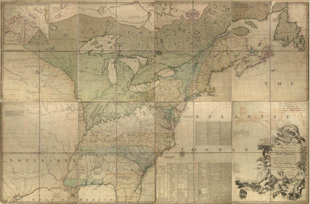
I am obsessed with maps. I find them incredibly interesting, especially old ones. After looking through the Digital Public Library of America for some time, I ended up coming across this beautiful map from 1755 of British and French territories in North America. The great thing about this map is that we are shown the differences in territories when compared to today. For example, South Carolina and North Carolina have essentially the same borders as today in the North, East, and South. But out West, it is all different. Their borders seem to extend all the way to the Mississippi river which is essentially where French Louisiana was. This makes complete sense considering that Louisiana was not acquired by the United States until the Louisiana purchase.
Another interesting aspect of this map is where Georgia is. Georgia is incredibly small compared to what it is today. This seems to be because of Spanish Florida which cuts off a lot of what Georgia is today. Throughout the Western section of the map there are also indications of where certain Native American tribes are. The map is also incredibly detailed with a huge amount of information written throughout such as longitude observations and cities in towns being identified all along the Eastern territories.
The legend of the map tells all the information it contains. It is as follows: cities, capitals, towns, villages, Indian villages, Indian towns, Indian forts, roads and their distances, waterfalls, and rivers. We also see the majority of French territories up north towards Canada. This map puts a lot of history into perspective since it shows us three world powers who no longer hold any of the territories shown on the map. However, I do think that there is still a French overseas territory in Canada that is shown on this map. But that is tiny and almost not worth mentioning. This illustrates to the average viewer of this map how much the world has shifted since the colonial period and also the failure of colonial powers to maintain their hold on their colonies.
But the most interesting thing to me about this map is how it is truly a work of art. Modern maps are very bland and have the objective of only presenting information. However, this map, like most old maps, has extensive decoration and designs throughout. The main drawing is located on the bottom right corner. The best way I can describe it is as a mixture of enlightenment art and tropical themes with nude women and cherubs. The letters are also incredibly ornate and flowery.
Altogether, I love old maps such as this one because they are not only filled to the brim with information but also pleasing to look at due to them essentially being works of art as well.