BEAMS Program Student Research Posters
Multibeam sonar data used for these research projects were collected by the R/V Celtic Voyager and R/V Celtic Explorer as part of Ireland’s goal to map and characterize all of its marine territory (10 times the size of Ireland!). This program, INFOMAR is a collaboration between the Marine Institute of Ireland and Geological Survey of Ireland.We are very grateful for our continued collaboration with INFOMAR, which has allowed for participation at-sea by 8 BEAMS students. |
 |
Continental margins are the submerged edges of a continent, with areas known as the shelf (closest to shore), slope and rise. Water depths on margins extend to beyond 3 km.
BEAMS students assisted with recent high-resolution mapping around Ireland’s perimeter, on the continental shelf, where depths are <300 m.
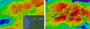
The map below shows the regions included in studies by students, followed by links to posters.

Ireland’s Continental Margin Study Areas
Nearly all posters were presented by students at a national or international conference, as indicated in parentheses.
~~~~~~~~~~~~~~~~~
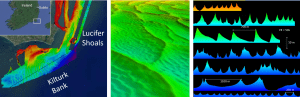
Geomorphological Analysis of Complex Sediment Waves in Southeastern Ireland:
(Lucifer Shoals (Part 1) and Kilturk Bank (Part 2)
Alexandra Dawson and Dr. Leslie R. Sautter (OCEANS 2018, Charleston and 2018 Ocean Sciences Meeting, Portland)
~~~~~~~~~~~~~~~~~
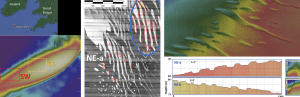
Geomorphological Analysis and Characterization of Labadie Bank in the Celtic Sea
Luke Hollahan and Dr. Leslie Sautter (2018 Ocean Sciences Meeting, Portland)
~~~~~~~~~~~~~~~~~
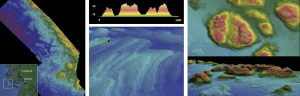
Glacio-Karst Limestone and Jointing of Inishmore, Ireland
Robert J. Kozich and Dr. Leslie Sautter (2017 US Hydro Meeting, Galveston)

~~~~~~~~~~~~~~~~~
Bathymetric and Geomorphological Analysis of Inishmore Island, Ireland
Treyson Gillespie and Dr. Leslie Sautter (2017 US Hydro Meeting, Galveston)

~~~~~~~~~~~~~~~~~
Topographic and Morphologic Variations in Bathymetry Between and Galway Bay Bertraughboy Bay
Luke Hollahan and Dr. Leslie Sautter (2017 US Hydro Meeting, Galveston)
~~~~~~~~~~~~~~~~~
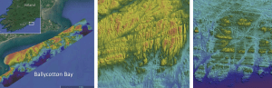
Analysis of Structural Geomorphology in Ballycotton Bay Bedrock on the South Irish Coast
Hayley Drennon and Dr. Leslie Sautter (2017 US Hydro Meeting, Galveston)
~~~~~~~~~~~~~~~~~
Structural Mapping and Geomorphology of Ireland’s Southwest Continental Shelf Using High Resolution Sonar
Shelby Bowden, Rachel Wireman, Dr. Leslie Sautter, Dr. Erin Beutel, and Dr. Norman Levine (2016 Ocean Sciences Meeting, New Orleans)

~~~~~~~~~~~~~~~~~
Bathymetric Terrain and Substrate Characterization in Killary Harbour, Ireland
Logan Crouse and Dr. Leslie Sautter (2016 Ocean Sciences Meeting, New Orleans)

~~~~~~~~~~~~~~~~~
Geomorphology of Killary Harbour, Ireland: Potential Effects of Rocky Outcrops on Surrounding Sediments
J. Ryan Hawsey and Dr. Leslie Sautter (2016 Ocean Sciences Meeting, New Orleans)

~~~~~~~~~~~~~~~~~
Bathymetric and Geomorphologic Characterization of the Mouth of Shannon, Ireland
Victoria Houston and Dr. Leslie Sautter (2015 US Hydro Meeting, Washington, DC)
~~~~~~~~~~~~~~~~~
Geomorphology of the Continental Margin off the Dingle Peninsula, Ireland
Hannah Yates and Dr. Leslie Sautter (2015 US Hydro Meeting, Washington, DC)

Many thanks to our Marine Institute of Ireland colleagues!
![]()
![]()
![]()
