


Archives For November 30, 1999
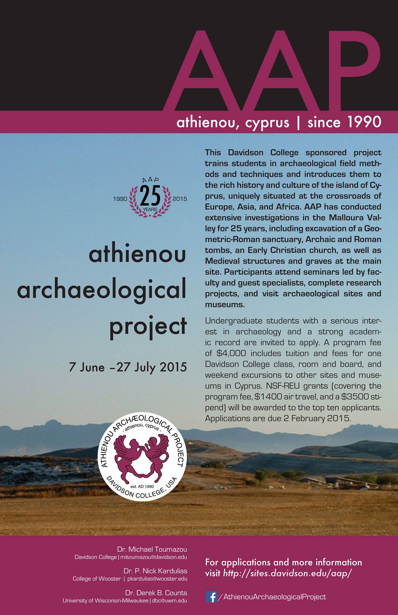
The Athienou Archaeological Project (AAP) is pleased to announce its 2015 Archaeological Field School, sponsored by Davidson College and generously supported by Davidson College, the National Science Foundation and the town of Athienou. The 2015 season, our 25th(!), will run from June 7, 2015 through July 27, 2015.
A grant from the National Science Foundation (REU) will provide the top ten applicants with full scholarships covering tuition/program fees, room/board, air travel and a $3500.00 stipend. NSF fellows must be US citizens who are enrolled as undergraduate students for the duration of the program; there is no separate application for the NSF-REU–all applicants who meet the criteria will be considered.
General information about AAP can be found at our www site:
http://sites.davidson.edu/aap/
Students are also encouraged to follow AAP on Facebook.
To apply:
https://davidson.studioabroad.com/index.cfm?FuseAction=Programs.ViewProgram&Program_ID=37617
Participants in the program join AAP in its 25th campaign year. The Project involves excavation at the site of Malloura (occupied from the Geometric through Ottoman periods – 8th century B.C. to 19th century A.D.) and field survey of the surrounding valley in south central Cyprus. The site’s long occupation period, coupled with the diversity of archaeological remains encountered — domestic, religious, and funerary — make it an ideal training ground in archaeological methodology.
Participants attend seminars led by faculty and resident or guest specialists, complete an independent research project, and visit archaeological/historical sites (e.g., Khirokitia, Kalavassos, Amathous, Kition, Kourion, Paphos, Kolossi, Asinou, etc) around the island. Students live in the small town of Athienou and learn about life in modern Cyprus. A three-day break in the program gives students the opportunity, if they wish, to visit Mediterranean destinations close to the island.
The Athienou Archaeological Project (AAP) is a multidisciplinary project focusing on the site of Athienou-Malloura and the surrounding valley in south-central Cyprus. AAP is directed by Michael K. Toumazou, assisted by Derek B. Counts (University of Wisconsin-Milwaukee), P. Nick Kardulias (College of Wooster), Erin W. Averett (Creighton), Clay M. Cofer (Bryn Mawr), and Jody M. Gordon (Wentworth Institute of Technology).
For AAP’s latest research, see Crossroads and Boundaries: The Archaeology of Past and Present in the Malloura Valley, Cyprus (Boston, 2011): http://www.isdistribution.com/BookDetail.aspx?aId=14366
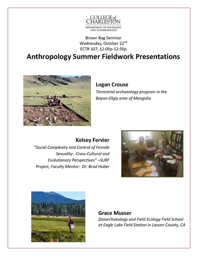
Next week Logan Crouse is scheduled to present on his field work in Mongolia, an experience the Archaeology Program helped make possible by supporting his travel expenses.
Link to original content: http://www.forbes.com/sites/emc/2014/07/09/using-big-data-and-satellites-to-uncover-clues-to-ancient-greece/
By Michael O’Dwyer
In blockbuster productions, Hollywood’s depiction of archaeologists stretches the truth more than a little. In reality, archaeologists are less like Indiana Jones or Lara Croft. Rather, they can be found living lives that are focused primarily on the academic impact of their findings. However, new technologies are pushing the boundaries of what can be discovered, bringing a new level of excitement to the field.
Using satellite imaging, with a variety of sensor types and resolutions, modern day archaeologists can now map ancient cities and estimate the best locations for new digs. By combining information gathered via satellite — high-resolution photos in the visible and near infrared spectrum—with data analysis and manual surveys, archaeologists can more easily and safely uncover those lost civilizations.

Acropolis, Athens (photos source: iStock)
Using Satellites to Study Ancient Settlements
James Newhard, director of archaeology and associate professor of classics at the College of Charleston is working on several projects involving a variety of technologies that are shining new light on the ancient world.
The first involves designing a data system to study clay tablets depicting the oldest known form of Greek, from the Palace of Nestor in Pylos, Greece. Another is the Avkat Project, a field survey in Turkey examining a historical trade route that linked Europe with the Far East. Here, satellite imaging allows experts to distinguish settlements, from the late Roman to the Ottoman eras, by linking smartphone GPS information to satellite images.
Additional analysis on the images is then performed in the lab–due to the computing resources necessary. Since raw data files from satellites are several gigabytes in size, the systems require the same kind of processing power necessary for computer games, 3D rendering or animation. “Ultimately, [the same power as used for] high-end gaming systems are a minimum requirement,” says Newhard.
Knowledge of specialized applications—such as ERMapper for image processing, the geographic information system ARCGIS, and ENVI, for geospatial and spectral data analysis—has become essential for image analysis and mapping, as well.
“You are either proficient in a range of software applications or you involve someone that is, as computer skills are necessary to analyze the data received,” says Newhard.
Newhard regards satellite imaging as a powerful tool that allows him to accelerate fieldwork, reducing the time taken for on-site surveys that would normally have taken years.
“Archaeologists are consummate borrowers and thieves,” says Newhard. “If there is something out there that will help me tease out more data, I’ll use it, as we are dealing with scraps and fragments of the past.”
However, while technology is a useful tool, the essential ability to interpret the results requires expert knowledge and academic insight. Determining the origin of a ceramic piece, for example, requires certain language skills and knowledge of the historical period.
“How is your Byzantine Greek?” asks Newhard.
Technical challenges and commercial applications
Despite the gains technology offers archaeologists, sharing, comparing and merging data from different sources remains a challenge.
One of the obstacles in handling data is that the volume involved is sometimes larger than what a desktop computer can handle comfortably, says Richard Tipper, Ph.D., executive chairman at Econometrica, a specialist in environmental data, mapping and management solutions.
“A few terabytes of data is not unusual. Where it gets complicated is when an individual file exceeds 10 GB, often causing the system to crash,” Tipper adds.
Nigel Fox, head of earth observation and climate at the National Physical Laboratory says, “One of the challenges facing the earth observation community is how to store all of this data for the future.”
Experts must also select the best satellite for their tasks, as there are variations in resolution and accuracy. On-the-ground verification is recommended.
“You have got to be able to recalibrate the [satellite] sensor post-launch and also be able to validate what it is measuring with real information on the ground to link the two things together,” says Fox.
Newhard is ultimately looking forward to future technological advances, especially in the informatics and data processing areas. “The ability to virtualize a historical landscape in a 3D environment and incorporate everything found from historical tax records to artifacts and documents will allow a clear picture of the past.”
Michael O’Dwyer is a freelance writer living in Hong Kong. He spent over 15 years in the electronics industry, managing information technology, process improvement and supply chains. Michael writes for a variety of online portals on IT and related topics.
http://www.brockington.org/Careers/summary.php?j=126
(applications due June 18, 2014)
Brockington and Associates is seeking an experienced archaeological field and lab technician based in our Mt Pleasant, SC office. The position requires an individual with a bachelor’s degree in archaeology, anthropology, or a related field, and a minimum of field school or the equivalent field experience.
This job will require the successful applicant to perform both field and laboratory duties as needed.
Work schedule will include 40 hour weeks. No overtime is expected on these assignments. We will provide vehicles for daily travel between the project area and the office. Single- occupancy hotel rooms and meal allowance are provided when traveling is required. Brockington offers benefits including, health and dental insurance, 401K and paid vacation
About the Job:
Field responsibilities include the ability to conduct shovel testing and/or other unit excavations, artifact identification, note-taking, recording soil and other observations, field photography, use of handheld Global Positioning Systems devices, and general tasks under the direction of the Project Manager. Travel, physical labor, and time spent in outdoor conditions are a requirement of this job.
Lab responsibilities include complete processing of archaeological specimens (washing, labeling, cataloging, etc.) The successful applicant conducts all aspects of the management of archaeological collections including inventorying and preparation for long-term curation: primary sorting and preliminary analysis of archaeological artifacts, maintaining and verifying specimen logs and other documentation on archaeological projects, data entry, updating and verification of the archaeological database. Other responsibilities include assisting with and becoming familiar with more detailed artifact analysis, monitoring and upkeep the ongoing electrolysis conservation projects, artifact photography using digital imaging system, preparing related archival materials for long-term curation, and performing other related duties as assigned.
Driving required: Yes
Application due date: Applications must be received no later than 5:00 pm on June 18 or they will not be processed or considered.
Ten College of Charleston students presented research April 11-12, 2014 at the annual Colonial Academic Alliance Undergraduate Research Conference in Towson, Md. These scholars represent the best research papers submitted by students from all majors. The conference is the signature academic and outreach event sponsored by the Alliance, under the auspices of the Colonial Athletic Association, of which the College is a new member in 2013-14.
The conference included a keynote presentation by Don Thomas, a former NASA astronaut who now heads the Hackerman Academy of Mathematics and Science at Towson University.
“The Colonial Academic Alliance Research Conference provided an excellent opportunity for us to showcase the different types of research and creative projects on which College of Charleston students and faculty collaborate,” said Dr. Trisha Folds-Bennett, dean of the Honors College. “The group of students chosen to represent us were energetic, engaged, and professional. Professor Andrea DeMaria and I were both impressed with their contribution to the conference, and thank the Office of Academic Affairs for funding the trip.”
Student presenters from the College of Charleston included:
Jami Baxley (classics and archaeology; James Newhard, faculty adviser)
Alexandra Cattran (physics and astronomy; Linda Jones, faculty advisers)
Lance Cooper (political science; Gibbs Knotts, faculty adviser)
Colin Cotter (chemistry & biochemistry; Gamil Guirgis, faculty adviser)
Hannah Evans (English & African studies; Simon Lewis, faculty adviser)
Grace Moxley (chemistry and biochemistry; Andrea DeMaria and Beth Sundstrom, faculty advisers)
Jackelyn Payne (health and human performance and communication; Andrea DeMaria and Beth Sundstrom, faculty advisers)
Sarah Turner (biology; Allison Welch, faculty adviser)
Aleisha Walker (teacher education and sociology and anthropology; Christine Finnan, faculty adviser)
John Wise (religious studies; Katie Hladky, faculty adviser)
 College of Charleston sophomore Sarah Legendre is participating in a Fulbright Summer Institute, one of the most prestigious and selective summer scholarship programs operating worldwide. Legendre, an Honors College student and double major in geology and archaeology, will spend four weeks at Durham University in the UK. (read more)
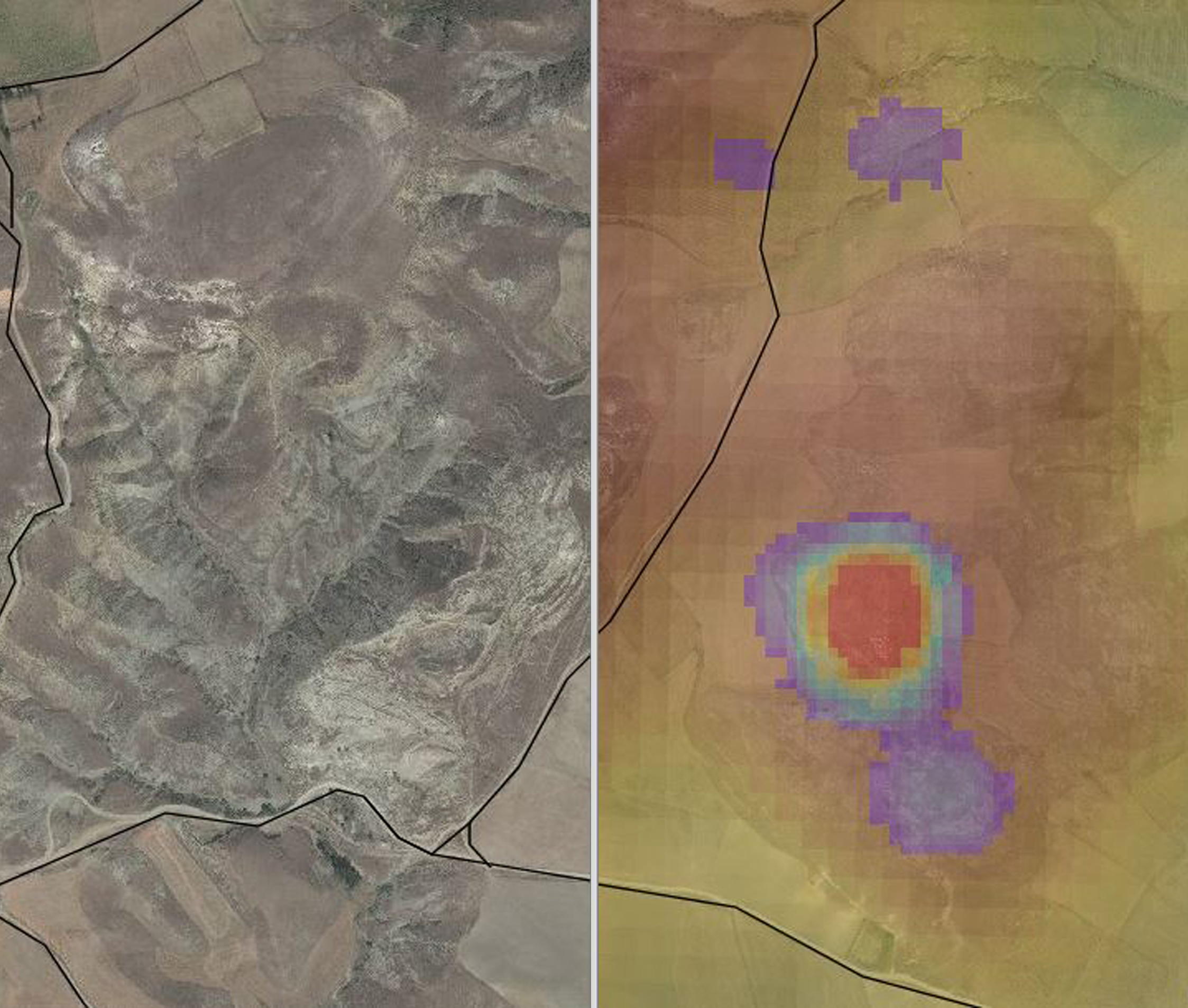
Satellite and Geospatial Imagery from the Avkat Archaeological Project.
You won’t always find James Newhard exhuming delicate artifacts with a trowel or handbroom.
For Newhard, director of the College of Charleston’s program in archaeology and associate professor of classics, the task of studying ancient civilizations is just as easily accomplished with the aid of geospatial 3D modeling, airborne drones, and 3-D or Reflectance Transformation Imaging (RTI). He works to find archaeological applications for cutting-edge technologies. (read more here).