Explore the Seafloor with the BEAMS Program!

Explore the Seafloor was created as a web resource for the public, students, educators and scientists to learn more about the seafloor of our global ocean. On this site you will be able to find maps, photos, movies, research project posters, and image galleries that highlight recent exploration of the deep ocean. Multibeam sonar data collected by numerous vessels has been used to generate detailed seafloor maps of areas in both the Pacific and Atlantic Oceans, and incredible HD video footage collected by robotic vehicles called ROVs (Remotely Operated Vehicles) has allowed for a new perspective of the deep sea, opening our eyes to many amazing environments with complex geology and diverse biota.
Explore the Seafloor products were made by students and faculty of the College of Charleston’s BEnthic Acoustic Mapping and Survey (BEAMS) Program, housed and managed in the Department of Geology and Environmental Geosciences.
Sonar datasets used in the research and exploration projects were collected by numerous ships and investigators, and are available for download using the NOAA Bathymetric Data Viewer. Nearly all of the video products made for this website use data collected by the NOAA Ship Okeanos Explorer’s ROV Deep Discoverer.
NOAA Ship Okeanos Explorer
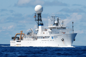 |
NOAA Ocean Exploration is responsible for operating the U.S. government’s only dedicated exploratory research vessel, the NOAA Ship Okeanos Explorer. Their efforts help to ensure that exploratory data is available to the general public.